Browser extension · 2GIS

2GIS scraper for Excel and Google Sheets

Collect publicly visible 2GIS business listings into a table. Research businesses inside buildings, products, jobs and address structure, then add signals from company websites.

7-day free trial: collect up to 1,000 business listings from maps (POI) for new accounts after email sign-in. No payment card is needed for the trial.

  • Available from the Chrome Web Store and Microsoft Edge Add-ons
  • Collection and tables stay local in your browser
  • Continue on Free
Collection result2GIS businesses
3 rows · demo
CSVXLSXGoogle Sheets
NameCategoryRatingReviewsStatus
North CoffeeCoffee shop4.8126Open
Line WorkshopRepairs4.684Open
Nearby PharmacyPharmacy4.7209Open 24 hours
Synthetic structure example. Filled fields depend on the public business listing.
29native field positions
108normalized map columns
300+cities in the 2GIS network according to its help centre

Straightforward pricing

How much the 2GIS scraper costs

Test the output on your own searches first. Then stay on Free, get a Day Pass or choose a monthly volume.

After the trial

Free

€0forever

  • Up to 300 business listings from maps (POI) per month
  • Basic table and CSV export
  • For small one-off checks

Regular collection

Data

€19per month

  • Up to 25,000 business listings from maps (POI) per month
  • CSV, XLSX, JSON and Google Sheets
  • Enrichment and advanced processing
Choose Data

About formats: XLSX and Google Sheets are available during the trial, with a Day Pass and on the Data plan. The permanent Free plan exports a basic CSV table. All plans and limits →

Three steps to a table

How collection works

01

Open 2GIS search results

Search for a category, building, business or local service in the city you need.

02

Start collection

The extension reads publicly visible listings from the open tab.

03

Review and export

Review addresses, branches, commercial sections and sources before exporting.

Interface and output

What 2GIS collection output looks like

Actual extension screenshots: the populated table and the export menu.

Catalogue verified 2026-08-21: 29 native field positions and up to 108 normalized map columns. Website enrichment is counted separately.
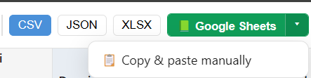
Table after collectionActual CrawlRover table with business rows, 2GIS fields and enrichment results.
Export a 2GIS result to Excel or Google Sheets
Export the resultChoose CSV, JSON, XLSX, Google Sheets or manual copy.

Click the table again, press Esc, or click outside to close

Decision guide

When to choose 2GIS

Start with the source that best matches your market and required fields. Use another map only for the gaps that matter.

300+ cities in the 2GIS network according to its help centre

City directories with local depth

RussiaKazakhstanBelarusKyrgyzstanUzbekistanAzerbaijanArmeniaGeorgia

2GIS is most valuable in cities where businesses are connected to buildings, entrances, floors and commercial sections.

Check availability for the exact city you need: some datasets are limited to populated areas where 2GIS is present.

2GIS Help on cities in its network · 2026-08-25 ↗

Best suited to

🏢B2B inside buildings

Collect tenants of shopping and office centres while preserving the connection between a company and its address.

🛍️Products and vacancies

Segment businesses by published products, prices and job openings to research local supply.

🏠Real estate and urban context

Use building and real-estate details as an extra layer of local market analysis.

Strengths

🏢Businesses in a building

Connections to shopping centres, office buildings and other properties reveal local business clusters.

📐Detailed addresses

Address components, floors and entrances provide a deeper structure for validating a location.

🛍️Commercial sections

Products, prices and vacancies let you segment beyond the top-level category.

🏠Buildings and real estate

Building attributes and property listings extend location-based research.

Limits to account for

Narrower geography than global maps

Outside covered cities, start with a map whose official coverage matches the target country.

No consistent average check

Yandex Maps can add local price context for service segmentation.

Fewer global metadata fields

Time zones and some international identifiers are easier to source from Google or Apple Maps.

Four data layers

Know where every value comes from

Map collection, website enrichment and calculated estimates answer different questions. CrawlRover keeps those layers conceptually separate.

01

Native 2GIS data

29 field positions and up to 108 normalized columns from public map listings.

02

Observable website signals

CMS, analytics, chats, booking, payment, domain and infrastructure signatures when a company website is known.

03

Calculated estimates

Digital maturity, website health and growth signals derived from available observations. These are estimates, not company-declared facts.

04

Fields from other maps

Selected gaps can be filled from the other supported maps when the same company can be matched with enough confidence.

How enrichment works →

Native map fields

What can appear in the table

29 field positions can expand into up to 108 normalized columns. A position is a business concept; columns are its separate exported values.

from map listing-dependent
Core data 7 positions
Name from map 3 col.
Category & rubrics from map 4 col.
Chain · branch count from map 1 col.
Address (full) from map 2 col.
Address components (region/street/house) from map 10 col.
Coordinates from map 2 col.
Card link · Place ID from map 4 col.
Contacts & channels 5 positions
Phones from map 3 col.
Website from map 2 col.
Company email listing-dependent 1 col.
Social profiles (company) from map 12 col.
Legal entity IDs (TIN/OGRN) listing-dependent 2 col.
Ratings & reviews 5 positions
Rating from map 2 col.
Review count from map 2 col.
Ratings · photos count from map 1 col.
Star distribution from map 1 col.
Reviews: text, dates, replies from map 9 col.
Hours, prices, services 5 positions
Opening hours from map 2 col.
Features & amenities from map 2 col.
Description · about from map 1 col.
Popular times (busyness) from map 3 col.
Menu from map 5 col.
Location & building 3 positions
Metro · nearby stops listing-dependent 1 col.
Businesses in building (mall/office) from map 1 col.
Building: year · floors · material from map 4 col.
Media & commerce 4 positions
Photos (albums) from map 6 col.
Products · prices from map 5 col.
Job openings from map 6 col.
Real estate + market estimate from map 11 col.

Verified catalogue: 2026-08-21. Filled fields depend on the public listing and collection scenario. Compare all five maps →

Website enrichment

Turn a map listing into a better-qualified company record

When the listing contains a public website, CrawlRover can inspect observable HTML and infrastructure signatures and return them in separate enrichment fields.

Analytics and advertising

Google Analytics 4Google Tag ManagerYandex MetricaMeta PixelMatomoHotjar

CMS and commerce

WordPress1C-BitrixTildaShopifyWixOpenCart

Chats, booking and payments

JivoSiteIntercomYCLIENTSbooking widgetspayment signatures

Domain and infrastructure

domain ageSSLDNSSPFDKIMDMARC
How to interpret the result

A detected HTML signature indicates that characteristic code was observed during the scan. It does not prove that tracking, payment or a widget is configured correctly at runtime. Digital maturity, website health and growth indicators are calculated estimates and should be used for prioritization, not as verified company statements.

Explore website enrichment fields →

Questions and boundaries

Questions about the 2GIS scraper

What is 2GIS best suited for?
It is useful for local B2B discovery, businesses inside buildings, products, vacancies, real estate and deep address structure in cities covered by 2GIS.
Does 2GIS offer the same depth in every country?
No. The network covers hundreds of cities, but individual datasets may exist only in specific populated areas. Check your target city before a large collection.
Which maps complement 2GIS data?
Yandex Maps can add average check and transport, Google Maps adds international identifiers, and Apple Maps adds time zone and partner actions.
Is there a free 2GIS scraper?
Yes. New accounts get a 7-day trial after email sign-in. You can then stay on Free for up to 300 map business listings per month and basic CSV export.
How much does the 2GIS scraper cost?
A 24-hour Day Pass is €9. The Data plan is €19 per month and includes up to 25,000 map business listings.
How do I export 2GIS to Excel or Google Sheets?
Open the map, start collection, review the built-in table and choose XLSX or Google Sheets. These formats are available during the trial, with a Day Pass and on paid plans.
Which browser package includes 2GIS?
2GIS is included in the published CrawlRover packages for Chrome and Microsoft Edge, as well as the full website package.
Can company websites add more fields to 2GIS rows?
Yes. When a public company website is known, CrawlRover can inspect observable technology, analytics, domain and business signals. Website enrichment uses a separate plan allowance by company.
Is CrawlRover an official 2GIS product?
No. CrawlRover is an independent tool and is not affiliated with 2GIS. Users decide their purpose and are responsible for source terms and applicable law.

Collect local businesses and building context from 2GIS

Test the result on your target city and category, then add selected price, global or website signals.

Five-map workflow

Compare another source before collecting

Each map has a different mix of geography and fields. Open the provider page that can answer your missing question.